

Every year come late summer and fall, Floridians brace for hurricane season. The first months of the Atlantic hurricane season, June, July, and August, are typically calm, but come September and October, the storms always seem to materialize. While it is rare to go a year without any storms forming in the Atlantic basin, some years are quieter than others. As anyone who’s been through a hurricane will tell you, though, it only takes one. Thankfully, St. Augustine and the Northeast Florida region have largely been spared direct hits by hurricanes. The last to make direct landfall in the area was Hurricane Dora in 1964. As residents of St. Augustine know, however, a storm does not need to make landfall to have serious impacts. Those of us who lived in the area through Hurricane Matthew (2016) and Hurricane Irma (2017) remember just how serious a brush from, or even an overland approach from a hurricane can be.
Hurricane Matthew began as a series of tropical thunderstorms off the west coast of Africa on September 23, quickly organizing and trekking towards the East Coast of the United States. It became a hurricane on September 29, and underwent a process of rapid intensification between September 30 and October 1. Matthew had become the southernmost category 5 storm in the Atlantic basin, maintaining category 4 or five strength for the longest of any hurricane in the eastern Caribbean Sea. As it moved over the Caribbean, it began to slowly weaken, though it remained at category 4 intensity. By early in the day on October 7, the storm was tracking along the eastern Florida coast. Matthew passed St. Augustine that day, approximately 30 miles offshore as a category 3 storm.
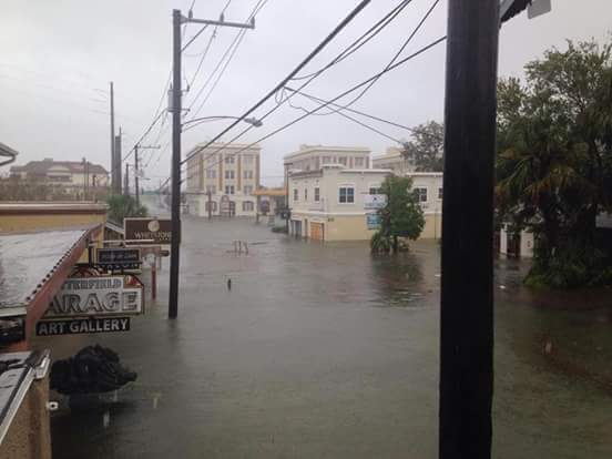
King Street Looking West During Hurricane Matthew, 2016
St. Augustine and St. Johns County saw substantial damage despite the worst remaining offshore. Matthew’s glancing blow brought the most significant impacts to the region since Hurricane Dora in 1964. Historic levels of storm surge flooded businesses and homes, and nearly ten inches of rain fell atop this tidal inundation. As a result, all seven of the city’s federally designated historic districts saw major flooding. A plaque at the Hilton on the bayfront denotes the high-water mark from the storm, approximately four feet high. Heavy winds in combination with all of the water brought down trees; portions of A1A were washed into the sea, and at Summer Haven, the storm carved a new tidal inlet. At the Historical Society, the Llambias House, the Tovar House, and the Gonzales-Alvarez House all saw substantial flooding. A preliminary damage assessment done by St. Johns County in November of 2016 following Matthew estimated damages totaling $138.7 million. Roughly a year later, St. Johns County would once again face extensive damage and flooding brought on by Hurricane Irma.
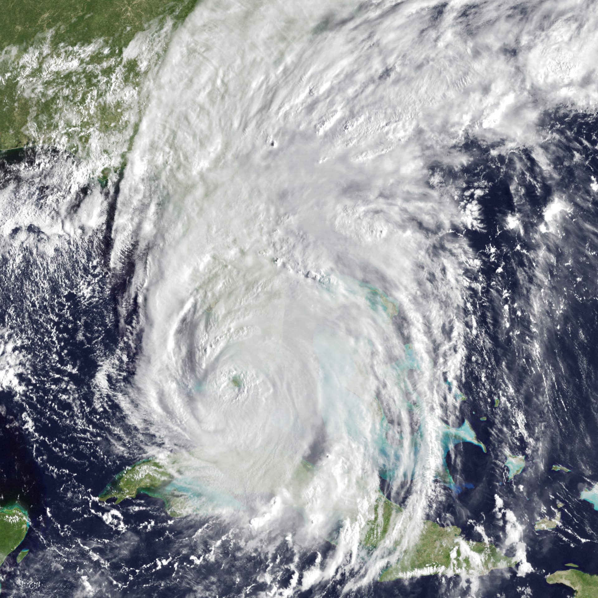
Satellite view of Hurricane Irma, September 10, 2017. Photo credit: NASA Earth Observatory.
Irma began much like Matthew, a wave of tropical thunderstorms off of the west African coast detected on August 27, 2017. Strengthening rapidly as it crossed the Atlantic, Irma achieved hurricane status on August 31, and reached peak intensity as a category 5 storm on September 5, before making landfall on Barbuda. Crossing the Caribbean while fluctuating between category 4 and category 5, Irma grew in size and began to turn towards Florida. Initial U.S. landfall was recorded in Cudjoe Key, with Irma a category 4 storm. The hurricane moved slowly northeast before turning back to the northwest across the state of Florida. Despite being spared a direct landfall, the east coast from Cape Canaveral to the Florida-Georgia border saw storm surge ranging from three to five feet as Irma passed over. Vilano Beach saw a 3.3-foot surge. Torrential rainfall and winds caused substantial flooding along the St. Johns River as well. In some places, the flooding brought on by Irma was worse than that of Hurricane Matthew the year before. St. Augustine measured 15.39 inches of rain from the storm in total. Three tornadoes were also spawned from Irma in St. Johns County, though only one of them caused significant damage. In total, Hurricane Irma caused some $32.7 million in damages in St. Johns County alone.
In two years, without making direct landfall in St. Augustine or St. Johns County, Hurricane Matthew and Hurricane Irma both caused substantial damage to the city and the county. Both storms today serve as a reminder that even a glancing blow or weakening system crossing over land can have tremendous impacts, and should always be taken seriously.
Written by Robert Covert, Collections Manager and Editor-in-Chief
Sources consulted:
Martin, Jake. “Hurricane Irma reimbursement process underway in St. Johns County.” staugustine.com. The St. Augustine Record. November 16, 2017. https://www.staugustine.com/story/news/local/2017/11/17/hurricane-irma-reimbursement-process-underway-st-johns-county/16288097007/?gnt-cfr=1&gca-cat=p&gca-uir=true&gca-epti=z113001e007100v113001d–30–b–30–&gca-ft=182&gca-ds=sophi
Cangialosi, John P., Latto, Andrew S., Berg, Robbie. National Hurricane Center Tropical Cyclone Report- Hurricane Irma, 30 August – 12 September 2017. National Hurricane Center, July 2026, updated. Accessed August 6, 2026. https://www.nhc.noaa.gov/data/tcr/AL112017_Irma.pdf
Stewart, Stacy R. National Hurricane Center Tropical Cyclone Report- Hurricane Matthew, 28 September – 9 October 2016. National Hurricane Center, April 2017, updated. Accessed August 6, 2026. https://www.nhc.noaa.gov/data/tcr/AL142016_Matthew.pdf
Brouillette, Daniel J. Hurricane Matthew- A Major 2016 Hurricane That Brushed Florida but Had Major Impacts. Tallahassee, FL: Florida Climate Center, Office of the State Climatologist, October 2016. Accessed August 6, 2026. https://climatecenter.fsu.edu/images/docs/Hurricane_Matthew_Florida_summary.pdf
Mariner, Cosmos. “Hurricane Matthew High Water Mark October 7, 2016.” HMdb.org. The Historical Marker Database, June 26, 2024. Accessed August 6, 2026. https://www.hmdb.org/m.asp?m=155131
Patterson, Steve. “St. Johns County estimates $120 million in storm damage to beaches.” Jacksonville.com. The Florida Times Union, November 1, 2016. Accessed August 6, 2026. https://www.jacksonville.com/story/news/2016/11/01/st-johns-county-estimates-120-million-storm-damage-beaches/15730020007/?gnt-cfr=1&gca-cat=p&gca-uir=true&gca-epti=z114201e003300v114201b0042xxd004265&gca-ft=166&gca-ds=sophi
Division of Water Resource Management, Florida Department of Environmental Protection. Hurricane Damage Assessment Report for 2016: Florida’s Beaches and Dunes. Tallahassee,FL: Florida Department of Environmental Protection, July 2017. Accessed August 7, 2026. https://floridadep.gov/sites/default/files/HurricaneDamageAssessmentReport_2016_0.pdf
Brouillette, Daniel J. Hurricane Irma: Florida’s First Landfalling Major Hurricane Since 2005. Tallahassee, FL: Florida Climate Center, Center for Ocean-Atmospheric Prediction Studies, Florida State University, December 2017. Accessed August 7, 2026. https://climatecenter.fsu.edu/images/docs/Irma_Fla_summary.pdf